المدة الزمنية 16:25
IPhone 13 Pro vs iPhone 14 Pro - LiDAR and Camera Mapping Accuracy
تم نشره في 2022/11/12
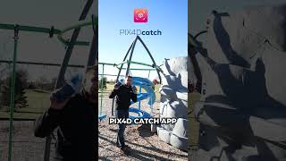
Join me on Social Media: 🖥️ Website: https://www.tamimi.biz 👤 Facebook: https://www.facebook.com/tamimibiz 👕 Survey Shirts - https://www.SurveyShirts.com 👥 Private Facebook Group: https://www.facebook.com/groups/iamasurveyor 📸 Instagram: https://www.instagram.com/ramitamimi 👔 LinkedIn: https://www.linkedin.com/in/ramitamimi ✉️ Email: rami@tamimi.biz Interested in attending GEOWEEK 2023? Use code RAMI100 for $100 off a conference pass OR a free exhibit hall pass. Sign up here - https://invt.io/1ixbktqnxjp 3D Scanner App: https://apps.apple.com/us/app/3d-scanner-app/id1419913995 Pix4Dcatch - https://apps.apple.com/us/app/pix4dcatch-3d-scanner/id1511483044 2-inch Reflective Targets - https://amzn.to/3SOL9ri CloudCompare - https://www.danielgm.net/cc/ Pix4Dmatic - https://www.pix4d.com/product/pix4dmatic-large-scale-photogrammetry-software Chapters: 0:00 Intro 1:05 Project Overview 3:16 LiDAR Scanning - 3D Scanner App 4:33 Camera + LiDAR - Pix4Dcatch 6:48 iPhone14 Pro 48 Megapixel 8:20 LiDAR Processing - CloudCompare 9:42 Camera + LiDAR Processing - Pix4Dmatic 11:40 48 Megapixel Camera Processing 13:07 Accuracy Analysis About Rami Tamimi: Rami Tamimi is an American doctorate student at The Ohio State University working towards his Doctor of Philosophy in Geodetic Engineering. With over a decade of experience in the Land Development Industry, his experience revolves around traditional field surveying, civil design work using AutoCAD Civil 3D, and geospatial technology including LiDAR, SONOR, and Photogrammetric data acquisition and processing with the use of Unmanned Aircraft Systems or Drones. He is also a University Instructor and creates instructional video content on YouTube. #iPhoneLiDAR #Surveying #iphone14pro
الفئة
عرض المزيد


تعليقات - 58
مقاطع الفيديو ذات الصلة على IPhone 13 Pro vs iPhone 14 Pro - LiDAR and Camera Mapping Accuracy: